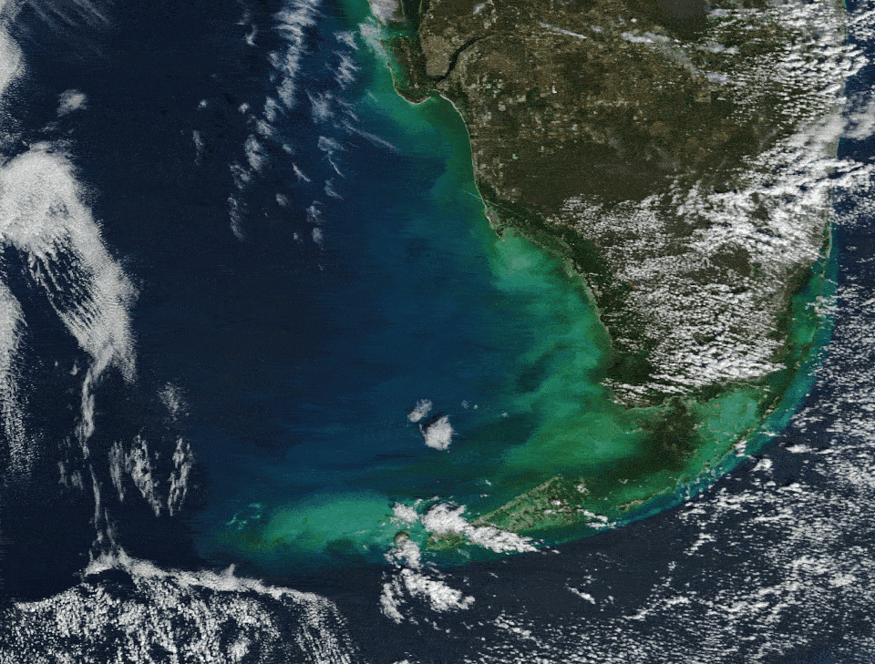
 A beautiful, pale blue plume of sediment appeared to glow off the southwest coast of Florida after a cold blast of Arctic air was pushed over the eastern U.S. by the polar vortex. (Image credit: NASA/Terra/Landsat) Share this article 0 Join the conversation Follow us Add us as a preferred source on Google Newsletter Sign up for the Live Science daily newsletter now
 Get the world’s most fascinating discoveries delivered straight to your inbox.
Become a Member in Seconds
Unlock instant access to exclusive member features.
Contact me with news and offers from other Future brands Receive email from us on behalf of our trusted partners or sponsors By submitting your information you agree to the Terms & Conditions and Privacy Policy and are aged 16 or over.You are now subscribed
Your newsletter sign-up was successful
Want to add more newsletters?
Join the club
Get full access to premium articles, exclusive features and a growing list of member rewards.
Explore An account already exists for this email address, please log in. Subscribe to our newsletter QUICK FACTSWhere is it? The Gulf of Mexico, off the Florida Keys [24.5786632, -82.52266106]
What's in the photo? A bright plume of calcium-carbonate-rich mud that was stirred up by a cold blast
Which satellite took the photo? NASA's Terra satellite
When was it taken? Feb. 3, 2026
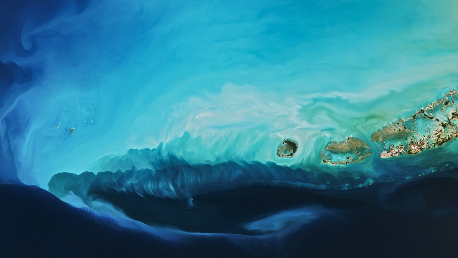
This striking satellite photo shows a bright plume of swirling marine mud that was whipped up off the coast of Florida following a blast of cold air from the Arctic, which brought severe winter weather to large parts of the U.S. earlier this year.
In late January, an extreme cold front descended across the eastern half of North America as the polar vortex — the ring of cold air that circles in the atmosphere above the Arctic — stretched southward, just as it did approximately a year previously.
This phenomenon, known as an Arctic blast, brought temperatures as low as minus 43 degrees Fahrenheit (minus 42 degrees Celsius) to parts of the Midwest, according to the National Weather Service's Weather Prediction Center. It also sparked fears that trees might start exploding.
Article continues belowIn addition to dumping snow as far south as Georgia, this weather front also helped create a giant underwater plume in the West Florida Shelf — a large area of shallow water created by a submerged continental shelf that extends off Florida's southwest coast.
The plume, which consists mostly of calcium carbonate scattered across the seafloor, stretched up to 150 miles (240 kilometers) from the coast at its widest point, which extended outward from Key West (partly visible as three large landmasses in the right of the photo), according to NASA's Earth Observatory. It also stretched around the same distance from north to south (beyond the upper border of the photo).
Calcium carbonate (CaCO3) is an inorganic chemical compound. While it is commonly found in rocks, such as limestone, the swirls in the photo are made of biological CaCO3 — created by corals, algae and crustaceans — that builds up on the seafloor as the creatures die and fall to the ocean floor. The West Florida Shelf collects high levels of this material due to its shallow waters and is often described as a "carbonate ramp" as a result.
When the cold Arctic air descended on North America, it triggered strong winds across the shelf's surface, which created currents that dragged the calcium carbonate and other seafloor sediments closer to the surface, James Acker, a chemical oceanographer at the University of South Florida and NASA's Goddard Earth Sciences Data and Information Services Center, told the Earth Observatory.
Sign up for the Live Science daily newsletter nowContact me with news and offers from other Future brandsReceive email from us on behalf of our trusted partners or sponsorsSimilar plumes have appeared in this area after hurricanes, which can also whip up seafloor sediments. However, such plumes are often less intricate than the one in this image because the disturbance to the ocean floor is much more violent.
Recent research has suggested that Arctic blasts like the one that painted this plume could become more common in the future as a result of human-caused climate change, which has made it more likely that the polar vortex will stretch southward. Therefore, we may see many more seascapes like this in the coming decades.
Hidden details
The plume is most highly concentrated in a line stretching directly between Key West and Dry Tortugas National Park, which comprises seven small islands (visible in the left of the photos).
Faint sediment swirls can also be seen farther from the coast. They include a rare pair of counter-rotating eddies, also called a "hammerhead eddy" (visible in the upper left of the image), which was created when the cold waters of the plume collided with the warmer waters in the Gulf of Mexico, according to the Earth Observatory.

This swirling sediment is also partly tied to the cold weather. "The cold air cools off the shallow water on the banks and makes it denser than the surrounding warmer open ocean water," Acker said. When this dense water sinks and flows offshore with the tides, it can carry some of the sediment toward the shelf’s edge, he added.
In the opposite direction, a thin trail of sediment can be seen snaking beneath the plume and terminating in a distinctive curl. This "loop current" formed when sediment-filled water spurted into the deeper waters of the Atlantic Ocean through hidden channels in the shelf's floor.
The last time such a visible loop current was seen in this area was in the aftermath of Hurricane Ian, which bashed into Florida in 2022 after pummeling Cuba, according to the Earth Observatory.
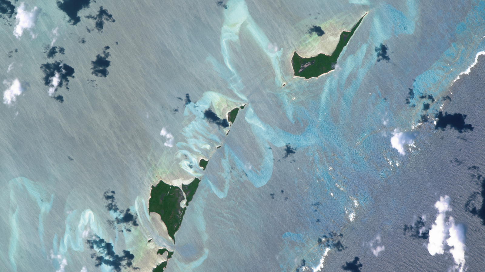
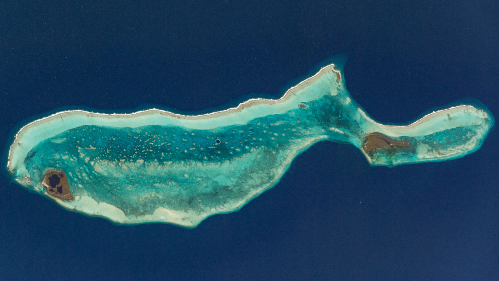 Whale-shaped island in Belize
A 2020 astronaut photo shows the unusual cetacean-like shape of Belize's Lighthouse Reef. It's home to the famous Great Blue Hole, which doubles as the island's "blowhole" when viewed from space.
 Sandbanks shine in Bahamas
A 2016 astronaut photo of the Bahamas shows a series of luminous, rippling sandbanks partly carved out by a coral reef. The image also reveals subtle differences in the ocean's surface caused by a steep, hidden ocean drop-off.
 Perfect island trio off Australia
A 2011 astronaut photo shows the atolls of Rowley Shoals lined up in a near-perfect line off the coast of Australia. The island trio was once part of an ancient barrier reef system that stretched over 1,200 miles.
TOPICS Harry BakerSenior Staff Writer
Harry is a U.K.-based senior staff writer at Live Science. He studied marine biology at the University of Exeter before training to become a journalist. He covers a wide range of topics including space exploration, planetary science, space weather, climate change, animal behavior and paleontology. His recent work on the solar maximum won "best space submission" at the 2024 Aerospace Media Awards and was shortlisted in the "top scoop" category at the NCTJ Awards for Excellence in 2023. He also writes Live Science's weekly Earth from space series.
View MoreYou must confirm your public display name before commenting
Please logout and then login again, you will then be prompted to enter your display name.
Logout LATEST ARTICLES 1Chemistry student develops clear polish that turns your fingernail into a touch-screen stylus
- 2Artemis II: NASA's first crewed mission to the moon since 1972
- 3Russian rocket en route to ISS suffers major antenna glitch, triggering remote-control astronaut 'backup plan'
- 4Antarctica could warm 1.4 times faster than the rest of the Southern Hemisphere in the coming decades, study finds
- 5Watch sperm whale headbutt another for no apparent reason