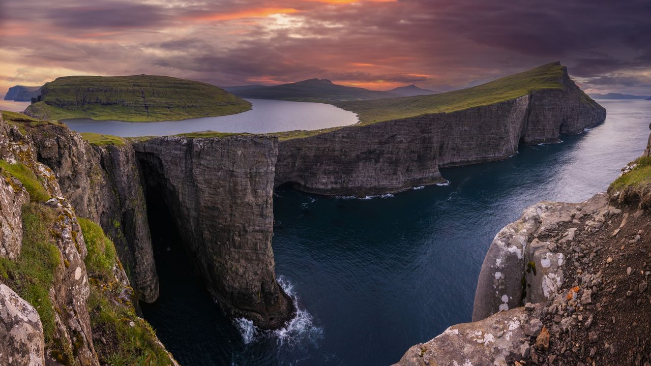
 Viewed from a certain angle, one side of Sørvágsvatn (Leitisvatn) looks like it's floating above the ocean. (Image credit: Anton Petrus via Getty Images) Share this article 0 Join the conversation Follow us Add us as a preferred source on Google Newsletter Get the Live Science Newsletter
 Get the world’s most fascinating discoveries delivered straight to your inbox.
Become a Member in Seconds
Unlock instant access to exclusive member features.
Contact me with news and offers from other Future brands Receive email from us on behalf of our trusted partners or sponsors By submitting your information you agree to the Terms & Conditions and Privacy Policy and are aged 16 or over.You are now subscribed
Your newsletter sign-up was successful
Want to add more newsletters?
Join the club
Get full access to premium articles, exclusive features and a growing list of member rewards.
Explore An account already exists for this email address, please log in. Subscribe to our newsletter QUICK FACTSName: Sørvágsvatn or Leitisvatn
Location: Vágar, Faroe Islands
Coordinates: 62.0496, -7.2362
Why it's incredible: The lake looks like it's hanging over the ocean.
Sørvágsvatn, also called Leitisvatn, is a 1.3-square-mile (3.4 square kilometers) lake in the Faroe Islands that appears to float above the sea.
Article continues below 
Locals disagree about the name of the lake, hence why there are two. The inhabitants of Sørvágur, a village to the west of the lake on the island of Vágar, prefer the name Sørvágsvatn, which means "the lake by Sørvágur." People living in Miðvágur and Sandavágur to the east of the lake on Vágar call it Leitisvatn, or "the lake by Leiti," in reference to a territory in the east of the Faroe Islands.
The village of Miðvágur is closer to the lake than Sørvágur is, but the latter is thought to have been settled earlier during the ninth century, complicating the picture. Another argument in favor of calling the lake Sørvágsvatn is that the Faroe Islands' first settlers divided Vágar into three equal regions — and the lake is situated in the same region as Sørvágur.
MORE INCREDIBLE PLACES—Sistema Ox Bel Ha: A vast hidden system that's the longest underwater cave in the world
But to avoid this debate, locals mostly refer to the lake as Vatnið, meaning simply "the lake."
The lake is surrounded by cliffs, which creates the impression that it is higher above the waves than it actually is. This is especially the case on either side of the lake's primary outlet, a 100-feet-high (30 m) waterfall called Bøsdalafossur, meaning "the waterfall at Bøsdal," referring to the area near the settlement of Bøur.
Sign up for the Live Science daily newsletter nowContact me with news and offers from other Future brandsReceive email from us on behalf of our trusted partners or sponsorsDiscover more incredible places, where we highlight the fantastic history and science behind some of the most dramatic landscapes on Earth.
TOPICS Sascha PareStaff writer
 Sascha is a U.K.-based staff writer at Live Science. She holds a bachelor’s degree in biology from the University of Southampton in England and a master’s degree in science communication from Imperial College London. Her work has appeared in The Guardian and the health website Zoe. Besides writing, she enjoys playing tennis, bread-making and browsing second-hand shops for hidden gems.
View MoreYou must confirm your public display name before commenting
Please logout and then login again, you will then be prompted to enter your display name.
Logout LATEST ARTICLES 1Computing power is no longer the AI bottleneck — it's energy production
- 21,900-year-old double Scythian burial in Ukraine contains toxic red mineral
- 3Exceptionally rare sighting of planets colliding may shed light on the crash that formed the moon
- 4Children wearing bronze 'warrior' belts discovered in 2,500-year-old cemetery in Italy
- 5'Blackwater' lakes and rivers in the Congo Basin are now emitting ancient carbon into the atmosphere