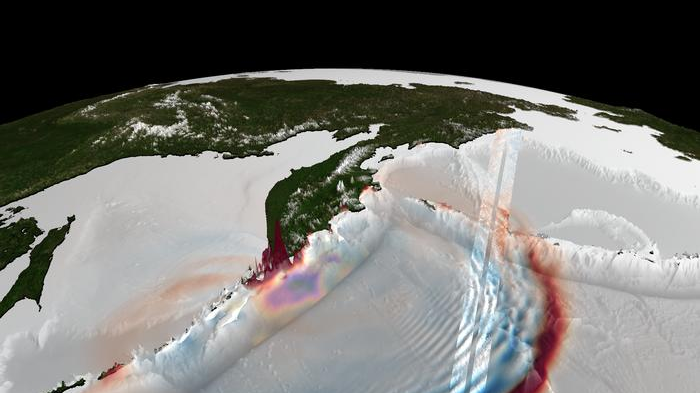
 About 1 hour after the earthquake, SWOT captured the offshore tsunami wave field near Kamchatka shown as two red–blue measurement swaths. These data constrained the inferred initial tsunami sea-surface elevation (yellow–purple pattern) and enabled forward simulations that reproduce the surrounding (red–blue) tsunami wave field in agreement with the SWOT observations. (Image credit: Bjarke Nilsson) Share this article 0 Join the conversation Follow us Add us as a preferred source on Google Newsletter Get the Space.com Newsletter
 Breaking space news, the latest updates on rocket launches, skywatching events and more!
Contact me with news and offers from other Future brands Receive email from us on behalf of our trusted partners or sponsors By submitting your information you agree to the Terms & Conditions and Privacy Policy and are aged 16 or over.You are now subscribed
Your newsletter sign-up was successful
Want to add more newsletters?
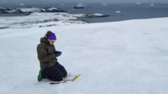
An account already exists for this email address, please log in. Subscribe to our newsletterLate on July 29, 2025, the Earth's crust off of Russia's Kamchatka Peninsula ruptured. Deep beneath the Pacific, along a subduction zone where one tectonic plate dives beneath another, a strain that had built up over decades was released in seconds. That rupture, a powerful magnitude 8.8 earthquake, displaced the seafloor and the water column above it, resulting in a tsunami. The tsunami radiated outward across the Pacific, racing across the open ocean as fast as an airplane and eventually surging onto the shore, reaching heights exceeding 55 feet (17 meters).
Scientists have long understood this chain reaction, but a detailed look at how an earthquake-tsunami event unfolds at the source — a subduction-zone trench — has remained difficult to achieve. There aren't enough tsunami-monitoring sensors near the trenches to get a clear look.
Rather than relying on purpose-built tsunami detection systems alone, researchers are increasingly turning to existing satellite missions and finding novel ways to use them. NASA and the French Space Agency's Surface Water and Ocean Topography (SWOT) satellite, originally designed to study global water levels and ocean circulation, is now proving to be a powerful tool for tsunami science as well.
A team of researchers led by Ignacio Sepúlveda of San Diego State University, used SWOT to observe the Kamchatka tsunami, and their resulting work gives an unusually clear view into tsunamigenesis, or the birth of a tsunami. Using satellite data, tsunami and earthquake researchers can better model — and hopefully better forecast — these extreme ocean events.
Sepúlveda, who leads the SDSU Coastal Engineering Lab, has long used satellites to study ocean events. Because previous tsunami research tapped into SWOT for observations, Sepúlveda and his researchers knew they could use the satellite to see the Kamchatka event — and they had something of a lucky break.
Just 70 minutes after the earthquake, SWOT passed over the Pacific roughly 375 miles (600 km) from the epicenter, imaging in high detail not only the tsunami's leading wave, but also a train of smaller waves trailing behind it.
Get the Space.com NewsletterContact me with news and offers from other Future brandsReceive email from us on behalf of our trusted partners or sponsorsAs the team attempted to simulate the 2025 Kamchatka event, they ran into a problem. "When we reproduced the tsunami using our simplest model, the long-wave model that everybody uses extensively, we saw that the model was not reproducing all the properties that were observed by SWOT," Sepúlveda told Space.com.
The issue was those trailing waves, called dispersive waves. The long-wave model simply doesn't account for them, since dispersive waves are not easily observed with existing technology.
Traditional tsunami monitoring relies heavily on Deep-ocean Assessment and Reporting of Tsunamis (DART) buoys, which measure pressure changes at the seafloor. While crucial for tsunami warnings, these sensors are limited in what they can detect. DART buoys provide measurements at single points, so it's impossible to "see" the full structure of a tsunami.
By contrast, SWOT offers a wide, two-dimensional view of the ocean surface, capturing wave direction, spacing, and curvature with centimeter-level precision. "Here, we have extra information coming from the satellite that we are not commonly getting from other types of instruments," said Sepúlveda. "With that 2D image, you are able to characterize very well what happened with the tsunami's leading wave and the trailing waves."

Sepúlveda and his team realized they needed to use a different model — the more sophisticated Boussinesq-type model — to correctly reproduce the SWOT observations of the Kamchatka tsunami. That broader perspective allowed researchers to identify a key insight: the dispersive waves carry information about where the tsunami originated. Now, the team was able to pinpoint tsunamigenesis to within about six miles (10 km) of the trench, marking such a close-up view for the first time ever.
The findings mark a turning point in tsunami science. For the first time, scientists have direct, high-resolution, two-dimensional observations linking a tsunami's structure in the open ocean to the details of the earthquake that created it. "In the long term, we will improve our models because we will start to know much better what is going on in that near-trench area," said Sepúlveda.
By improving how scientists model tsunami generation — particularly the elusive near-trench processes, which produce some of the most dangerous tsunamis — these observations can help refine forecasting systems. Better models mean more accurate predictions of wave height, timing, and impact at coastlines. And when used in conjunction with other monitoring tools like DART buoys, that could translate into faster warnings, better evacuations and lives saved when the next major tsunami strikes.
 Stefanie WaldekContributing writer
Space.com contributing writer Stefanie Waldek is a self-taught space nerd and aviation geek who is passionate about all things spaceflight and astronomy. With a background in travel and design journalism, as well as a Bachelor of Arts degree from New York University, she specializes in the budding space tourism industry and Earth-based astrotourism. In her free time, you can find her watching rocket launches or looking up at the stars, wondering what is out there. Learn more about her work at www.stefaniewaldek.com.
View MoreYou must confirm your public display name before commenting
Please logout and then login again, you will then be prompted to enter your display name.
Logout MORE FROM SPACE... 1Watch Comet MAPS get destroyed by cataclysmic fragmentation near the sun
- 2'Unreal' solar eclipse: Artemis 2 crew just saw one of the rarest sights in spaceflight history
- 3The Artemis 2 astronauts just flew by the moon. Lunar scientists can't wait for what's next
- 4Artemis 2: A moon mission of many milestone firsts
- 5'This is really big stuff.' Trump hails NASA Artemis 2 astronauts after historic moon flyby feat